Shadyside at Adams Gulch
Winter Hike/Snowshoe
With sweeping views and diverse terrain, Adam’s Gulch stands out as one of the valley’s most popular year-round trailheads. Whether you’re looking for an easy, well-worn path or a challenging snowshoe ascent, you’ll find a trail that fits your ambition.
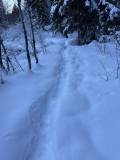
The Old Adam’s Gulch Road–Shadyside Loop is a great option for hikers who want an easy-to-follow route with a taste of forest snowshoeing. Unless there has been a very recent snowstorm, the first half mile is along a wide, well-defined path, followed by another half mile on a narrower but still compacted trail. Around the one-mile mark, the trail tightens and snowshoes may be helpful. By 1.5 miles, snowshoes are typically essential unless conditions are unusually dry.
The final two miles roll gently along the edge of a quiet forest. This section sees far less traffic, so be prepared to break trail.
While the route is easy when compacted, breaking trail with snowshoes dramatically increases the difficulty. Only experienced snowshoers should attempt it. If you’re looking for a fully compacted, easier option, try the Sunnyside–Old Adams Gulch Road Loop instead.
For additional routing support, use the “Route” tab below or go to this page at Trailforks.com and follow Old Adams Gulch Road to Shady Side Trail. For an offline map, download the Trailforks app.


3.5-mile loop
330 total elevation gain
Ascent Grade: 4.1% (Easy Hike/Moderate Snowshoe)
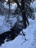
Except during very cold periods of winter, there is running water along most of the first portion of the route. The last mile or so of the hike follows a small stream, but it is usually frozen over.
From downtown Ketchum, it is an easy 2.7-mile drive with all but .2 miles being on paved roads. Click here for directions to the trailhead. There is generally plenty of parking during the winter.
There are bathroom facilities at the trailhead.
Dry Seasons: This route is an excellent option for hikers seeking a compact, easy-to-follow trail with a touch of forest snowshoeing.
Snowy Seasons: During snowy periods, only experienced snowshoers should continue past the 1.5-mile mark. Less experienced hikers should reassess at the one-mile point, as the next half mile includes sustained incline that can challenge even the fittest hikers.
For additional routing support, go to this page at Trailforks.com and follow Old Adams Gulch Road to Shady Side Trail. For an offline map, download the Trailforks app.
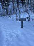
To begin, keep the large Adam’s Gulch trailhead sign to your right and follow the well-defined path. Quickly come to a bridge and after crossing it, turn right on Old Adam’s Gulch Road. The trail is well-traveled, so unless there is new snow, it is compacted and usually fairly wide. You will quickly pass an offshoot to Heidelberg Hill on your left, but stay straight.
Come to a signed Y-junction at .6 miles and stay left.
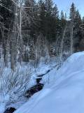
Just before the mile mark, cross over a small bridge. The stream below runs except in the driest and coldest years. At about the mile mark, come to another Y-junction. Stay left. Veering right will take you on a reverse route of the Sunnyside-Old Adams Gulch Road Short Loop.
The path usually narrows at this point and snowshoes will be helpful if there has been recent snow. With an oft-frozen stream to the left and a hillside rising to the right, the trail begins to roll. The rises sneak up on you and snowshoers breaking trail will see their heart rate spike.
At 1.6 miles, come to another signed Y-junction. Stay left on the trail less traveled. Showshoes may be required after this junction.
Curl down to the left, cross another small bridge and then come to another signed junction at 1.7 miles. Veer left onto Shadyside.
This is where things get really fun. This trail is less utilized and snowshoes are often necessary. Get your camera ready because it is a beautiful stretch of trail – the trees envelop you and a small stream sometimes runs alongside to your left.
Continue rolling and winding along the trail as it passes through the woods. If you are tired of breaking trail, there will be easy opportunities to jump back on Old Adam’s Gulch Road shortly before the 3-mile mark. If you stay on Shadyside, come to a signed junction with Heidelberg Hill at about 3.25 miles. Turn left and descend. About 50 steps later, come to another Y-junction and stay right. Follow the trail back to the parking lot.
Disclaimer: Trail info and routes on HikeSV.com are for reference only. Conditions, closures, and access may vary — plan ahead and hike smart!
Hike Categories
Distance: 0 to 4 miles
Difficulty: Easy,Moderate
Drive: Easy
Scenery: Nice
Shade: Moderate
Solitude: Moderate
Experience: Classics
Feature: Loop,Winter Hike/Snowshoe
Locations: Ketchum/SV